Geologic History
Ages and Types of Rocks
The rocks in the North Shore area mostly consist of Avalon and other types of granite, as well as calcgranofels and assorted mafic and metamorphic rocks. More specifically, mafic gneiss is a common rock found in the avalon terrane (Nevens, 61). Since rock evidence can tell a lot about the geologic history of a location, it is important to note the different types of rocks found in each geologic area we visited. The image below shows the different types of rocks in all of Massachusetts. Our research specifically focused on the North Shore area, which is the northeastern top of the state.
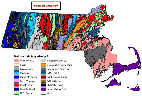
Source: http://www.mass.gov/anf/images/itd/massgis/datalayers/bedlith.jpg
|
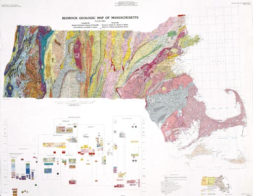
The rocks in Massachusetts are not all the same age. In fact, they have a huge range! The type of rock in an area can tell a lot about the geologic history of the location. For the locations we visited in the North Shore, the most prominent type of rock was granite. The rocks date back to the Proterozoic Eon and the Precambrian Era. The oldest of these rocks likely formed 2.5 billion years ago. |
Source: http://www.geo.umass.edu/stategeologist/frame_maps.htm
|
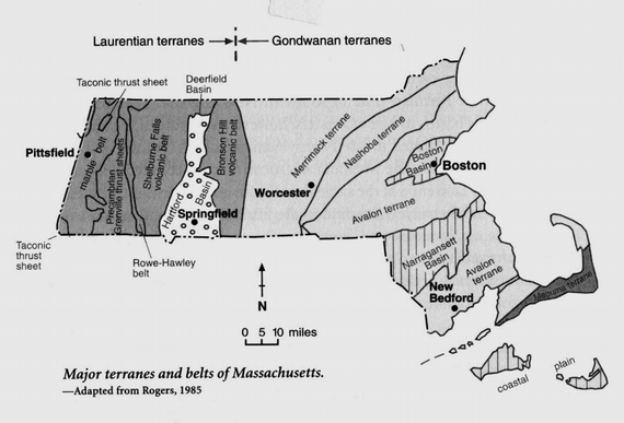
Avalon and Nashoba Terranes
Source: http://web.mit.edu/12.114/05_fall/www/nonGIS_data/worlds_end_bos_
basin_field_guide_sm.pdf
Massachusetts can be divided into several different areas by terrane, each of which has its own distinct rock types and history (Nevens, 57). The North Shore area consists mainly of the Avalon and Nashoba Terranes. "Avalon formed as a volcanic arc along the western margin of Gondwana in Late Proterozoic time" (Nevens, 57). Nashoba, located northwest of Avalon, most likely formed in the ocean near Gondwana (present-day Africa), similarly to the way Avalon formed (Nevens, 57). After their formation, they underwent several tectonic changes until they reached their present-day locations in the North Shore Massachusetts area.
History of the Laurentide Ice Sheet
The Laurentide Ice Sheet was a glacial complex that covered large portions of eastern, central and northern North America during the last glacial period. Originating on the Labrador-Ungava Plateau and on the mountains of the Arctic Islands of Canada, this glacial ice mass spread all the way down to what is now Cincinnati, Ohio. It occurred during the Pleistocene Epoch which was about 2,600,000 to 11,700 years ago (Fulton, 181). The ice sheet occupied an area more than 13,000,000 square kilometers, or 5,000,000 square miles, and contained an estimated 20 million cubic kilometers of water (Fulton, 185). In some areas, the ice sheet was 2,400 to 3,000 meters thick (Fulton, 185). This immense body of ice had a major impact on the level of the land, the oceans, the climate, and life.
This ice sheet was so large that it made the eustatic sea level decrease (on a global scale), since the ice was using up a portion of the ocean waters. It also caused an isostatic decrease (local scale) due to the enormous mass compressing the surface. After the ice sheet retreated, the land slowly started to rebound upwards, causing an isostatic increase in areas that used to be covered by the ice sheet. When the ice melted, the eustatic sea level increased because the water returned to the ocean.
This ice sheet was so large that it made the eustatic sea level decrease (on a global scale), since the ice was using up a portion of the ocean waters. It also caused an isostatic decrease (local scale) due to the enormous mass compressing the surface. After the ice sheet retreated, the land slowly started to rebound upwards, causing an isostatic increase in areas that used to be covered by the ice sheet. When the ice melted, the eustatic sea level increased because the water returned to the ocean.
|
In addition to changing sea and land levels, the ice sheet completely rearranged the surface of the land as it flowed across North America. It deposited fresh sediment and unweathered rock everywhere. As a result, the soil in the affected areas is young and rich in nutrients (Fulton, 185). The advance and retreat of the Laurentide Ice Sheet caused drastic changes in the coastlines over eastern North America.
The video on the right simulates the movement of the ice sheet. Notice the date in the bottom lefthand corner. |
Source: http://www.youtube.com/watch?v=wbsURVgoRD0
|
|
Please note it may take a moment to load.
|
Monthly averages of surface temperatures are commonly used to examine the annual evolution of the atmosphere. Click on the button on the left to view a series of images with information representing different aspects of the surface temperature 2 meters above ground level. The sea level pressure is represented by black contours and the 0 degree isotherm is represented by a white contour.
Source: http://polarmet.osu.edu/PolarMet/realtime/displaymod_paleo.php?var=slptempcolor |
|
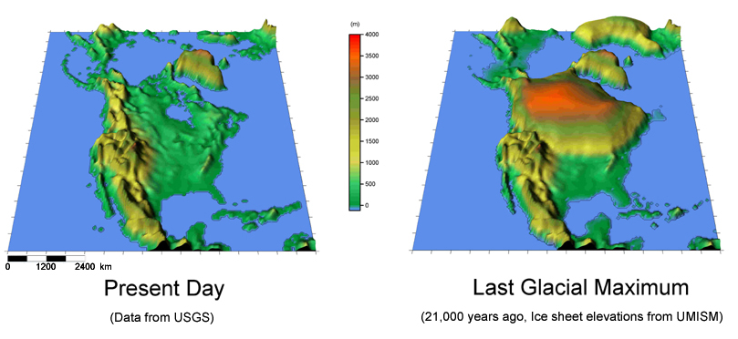
The image to the right shows the modern day topography (elevation) and the elevation at the time of the Laurentide Ice Sheet, during the Glacial Maximum. As shown, the ice sheet occupied almost all of Canada and extended into northeastern United States.
|
Source: http://polarmet.osu.edu/paleonwp/terrain.jpg
|
Oceanic Forces
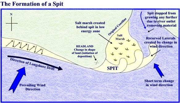
In addition to the Laurentide Ice Sheet, the coast of North America has also been greatly impacted by oceanic forces. The Atlantic Ocean has greatly affected the shape of the eastern coast. Longshore currents carry loose sediments parallel to the shore. These currents can form features such as spits, tombolos, and baymouth bars.
Source: http://www.slideshare.net/MsGeo/formation-of-spits-tombolos-and-bars-10001053
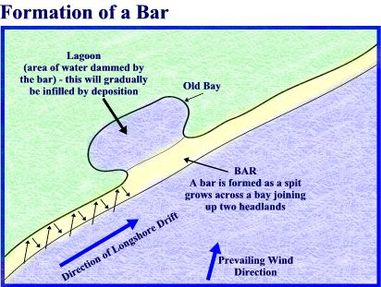
Baymouth bars are sandbars that completely cross a bay, sealing it off from the open ocean (Tarbuck, 691). They form from a growing spit that connects two areas of the mainland (Tarbuck, 419).
|
Source: http://www.slideshare.net/MsGeo/formation-of-spits-tombolos-and-bars-10001053
Spits are elongated ridges of sand that project from the land into the mouth of the adjacent bay (Tarbuck, 705). Tombolos form similarly to spits, except they extend far enough to connect two land bodies (for more information on tombolos click here).
|
These depositional features can be seen along the North Shore. For thousands of years, the strong ocean currents have transformed the coastline into unique, geological landmarks. The currents and the Laurentide Ice Sheet have both played influential roles on the shaping of America's eastern coast.
Tectonic Forces
|
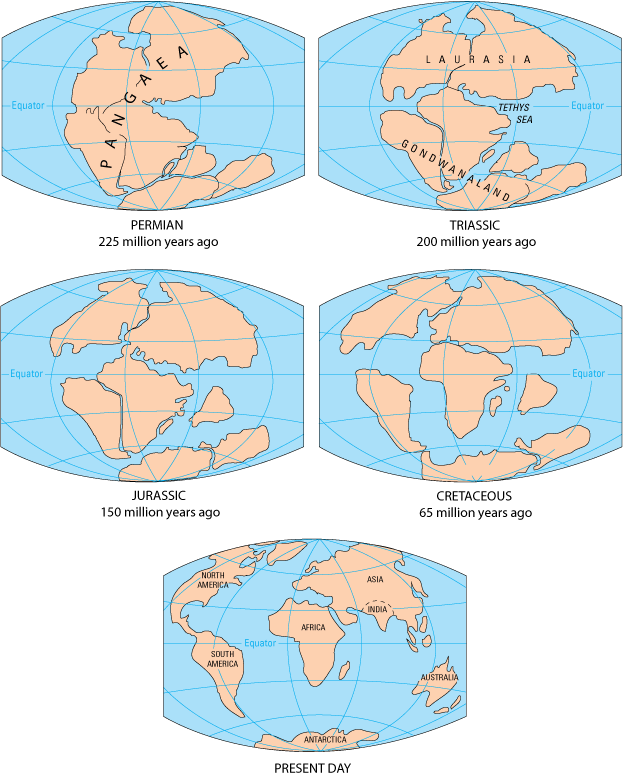
About 260 million years ago, all of Earth's land bodies were one giant mass known as Pangaea (Tarbuck 345). Pangaea was a supercontinent that means "all land" in Greek (Pangaea Theory). When Pangaea started to break up around 200 million years ago, it split into two large continents - Laurasia and Gondwana (Pangaea Theory). Laurasia and Gondwana continued to spread apart until they reached their present-day locations, and they continue to move today. The movement of the tectonic plates affected the North Shore area because it moved some of the continents farther north or south (away from the equator). For ice sheets and glaciers to form, it has to be cold enough for snow to form (below 32 degrees Fahrenheit or 0 degrees Celsius) and stick year round. The build up of snow leads to the formation of glaciers. The movement of the North American plate farther north allowed for the creation of the Laurentide Ice Sheet that then went on to dramatically change the surface of eastern North America.
|
Source: http://earthguide.ucsd.edu/eoc/teachers/t_tectonics/images/pangaea_gond.gif
|
